You are almost at the finish line of Weather and Nature Measurements — this is Lesson 4 of 5! Over the first three lessons, you built skills for reading and converting temperatures, and then moved on to interpreting rainfall and snowfall amounts. Now it is time to add another important piece of the forecast puzzle: wind speed.
Wind shows up in every weather report right next to temperature and precipitation, yet many people skip right past it. In this lesson, you will learn how to read wind values from forecasts, connect speed ranges to real-world effects you can see and feel, convert between miles per hour and kilometers per hour, and use all of that to make smart outdoor-activity decisions.
Why Wind Speed Matters
Temperature and precipitation tell you whether it will be hot, cold, wet, or dry, but wind adds a whole extra layer to how conditions actually feel. A calm 50 °F afternoon is pleasant for a walk, while the same temperature with 30 mph gusts can make you shiver and struggle to keep your hat on. Wind also affects safety: it can topple patio furniture, make driving a tall vehicle tricky, or turn a fun bike ride into a grueling workout.
Because wind influences comfort, safety, and planning, weather forecasts always include it alongside temperature and precipitation. Learning to read those numbers and know what they mean in practice is the goal of this lesson.
Be a part of our community of 1M+ users who develop and demonstrate their skills on CodeSignal
When you look at a forecast, you will usually see two wind values rather than one. Understanding the difference between them is the first step.
Sustained wind is the average wind speed over a short period, typically two minutes. This is the "baseline" speed that describes the overall wind condition.
Gusts are brief bursts that exceed the sustained speed, sometimes by a wide margin. A gust lasts only a few seconds but can be strong enough to catch you off guard.
A typical forecast line might read: "Wind 12 mph, gusts to 25 mph." Here, 12mph is the sustained speed and 25mph is the highest gust expected. Always pay attention to both numbers. Even if the sustained wind sounds gentle, high gusts can make conditions much more challenging.
Knowing that the wind is 15mph only helps if you can picture what that feels like outside. The table below connects common speed ranges to things you can actually see and feel, using miles per hour, the unit most common in U.S. forecasts.
Wind Speed (mph)
What You Notice
0–3
Calm. Smoke rises straight up and flags hang limp.
4–7
Light breeze. You feel wind on your face and leaves rustle gently.
8–12
Gentle breeze. Leaves and small twigs move steadily. Flags extend partially.
13–18
Moderate wind. Small branches sway, dust and loose paper blow around.
19–24
Fresh wind. Small trees begin to sway. Whitecaps form on lakes.
25–31
Strong wind. Umbrellas are hard to use. Walking into the wind takes effort.
32–38
Very strong. Whole trees sway and walking against the wind is difficult.
39+
Near gale or higher. Twigs and small branches break. Outdoor activity becomes unsafe.
You do not need to memorize every row. The key takeaway is that below about 12 mph feels light and manageable, 13 to 24 mph is noticeably windy, and above 25 mph starts to interfere with common outdoor activities.
The unit you see on a forecast depends on where it comes from, just as precipitation could appear in inches or millimeters. In the United States, wind speed is reported in miles per hour (mph). Most other countries use kilometers per hour (km/h). If you travel internationally or check a foreign weather app, you will need to move between the two.
The conversion factor is straightforward:
1mph≈1.6km/h
This means a wind speed in km/h will always be a larger number than the same speed in mph, much like how a distance in kilometers is a bigger number than the same distance in miles.
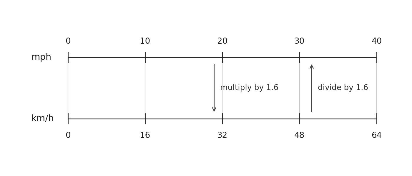
With the factor 1mph≈1.6km/h, the two conversion directions look like this:
km/h=mph×1.6mph=km/h÷1.6
Let's try a quick example in each direction.
mph to km/h: A U.S. forecast says winds of 20mph. To express that in km/h:
20×1.6=32km/h
km/h to mph: A European forecast reports 50km/h winds. To convert:
50÷1.6=31.25mph
For everyday weather decisions, we do not need decimal precision. Rounding 31.25 to 31 mph is perfectly fine. Weather forecasts themselves are rounded estimates, so matching that level of precision makes sense.
Multiplying or dividing by 1.6 in your head is not always easy. Here is a simple trick: multiply by 1.5 and then add a little. For example, if the wind is 20mph:
20×1.5=30,then add a bit≈32km/h
Going the other direction, you can divide by 1.5 and subtract a little. For 50km/h:
50÷1.5≈33,subtract a bit≈31mph
These rough estimates land close enough for practical planning. A few common benchmarks are also worth keeping in mind:
mph
km/h
10
16
20
32
30
48
40
64
Glancing at this short list can help you quickly place a km/h value into the right effects range from the table we saw earlier.
Now let's tie everything together. Suppose you are planning a weekend and the forecast looks like this:
Day
Sustained Wind
Gusts
Saturday morning
8mph
14mph
Saturday afternoon
18mph
28mph
Sunday
6mph
10mph
How would you use these numbers?
Saturday morning has a gentle breeze with mild gusts — fine for a bike ride or a picnic.
Saturday afternoon jumps to moderate sustained wind with gusts near 28mph. At that level, umbrellas become difficult and cycling into the wind is tiring. You might want to move lunch indoors or reschedule strenuous outdoor plans.
Sunday is calm, a great day for any outdoor activity.
The decision process is simple: compare the forecast values, especially the gust number, against the effects table. If gusts push into the strong-wind range (25mph or above), plan accordingly or choose a more sheltered activity. Notice that Saturday morning and Saturday afternoon look very different even though they are the same day, so checking the time-of-day breakdown matters.
In this lesson, you learned how to read sustained wind and gust values from a forecast. We connected wind speed ranges to practical effects you can see and feel, and you practiced converting between mph and km/h using the factor 1mph≈1.6km/h. Finally, we combined all of that information to make real outdoor planning decisions.
Up next, you will put these skills to work in a set of hands-on practice exercises. You will read forecast wind data, match speeds to their real-world effects, run conversions in both directions, and plan a weekend around the wind — let's see how it feels to be your own weather advisor!